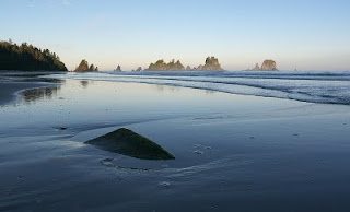
I had some questions after a post a while back about "sea stacks". You'll see a bunch of them below.
I'd seen some photos from here on Google Earth while researching Olympic National Park a month or so ago. I knew right then that I wanted to go there. BUT. And this is a huge "but", it is difficult to get there. It is at the far northwestern (read furthest point away on the Olympic peninsula) point, and the only access is after driving small, winding roads, to/through the Makah Indian Reservation where a recreation pass is required, then a two mile hike to the actual beach (Shi Shi Beach). Once on the beach, the Point of the Arches (sea stack formation) is another 2 miles away. This isn't a place to easily take Catherine and the kids.
So this past weekend, Catherine and the kids flew to Miami early Saturday morning, leaving me a weekend free to myself. Perfect timing!
I dropped them off at the Seattle airport and then picked up my stuff and made the long drive to Shi Shi beach and the Point of the Arches sea stack formation.

I had a blast shooting at sunset, and made sure to get up early for sunrise.
Lucky for me, it was still low tide in the morning, which opened up a lot more photographic possibilities. The rocks in the foreground are totally submerged, and the rock formations are completely surrounded by about 3-4 feet of ocean depth at high tide.
I did some more exploring in the area on Sunday, Cape Flattery on the northwestern-most tip of the lower 48 and the Sol Duc (or Sole Duck, depending on who you ask) region of the park.
Overall, a tiring weekend. But I wouldn't have it any other way. Shi Shi was awesome - I slept right on the beach which let me stay up late and wake up early and literally have 5 steps to where I wanted to stand to take photos.
Okay, okay. Enough talk about photography. Hopefully you all enjoy. I know I sure did.
Cheers,
Marc


No comments:
Post a Comment